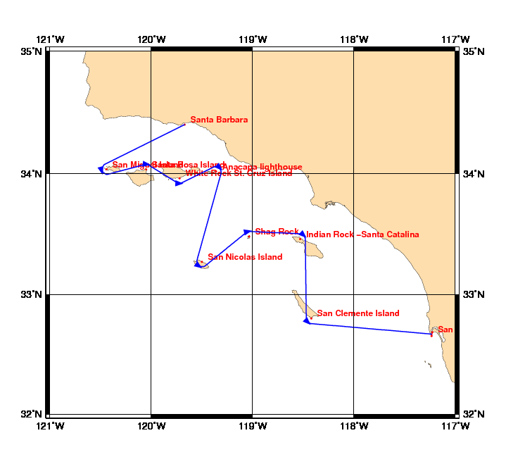
Chart and Info: Channel Island Ramble
Start time: Jan 19 2010 17:00:00 UTC

Start by Santa Barbara at position: 34N24.0000 119W40.2000

Marks:

BRG is the bearing from ship to mark at scoring position.

 1: San Miguel Island           - pass West  of 34N02.0220 120W26.5080 - BRG 075
 2: Santa Rosa Island           - pass North of 34N01.9800 120W03.0000 - BRG 187
 3: White Rock St. Cruz Island  - pass South of 33N57.6000 119W43.2000 - BRG 002
 4: Anacapa lighthouse          - pass North of 34N00.9480 119W21.5580 - BRG 224
 5: San Nicolas Island          - pass South of 33N16.2000 119W30.0000 - BRG 035
 6: Shag Rock                   - pass North of 33N28.8000 119W01.9800 - BRG 167
 7: Indian Rock -Santa Catalina - pass North of 33N27.6000 118W31.8000 - BRG 222
 8: San Clemente Island         - pass South of 32N48.0000 118W25.2000 - BRG 044

Finish line:

Line by San Diego between marks A and B at positions:

 A: 32N41.1936 117W13.6474
 B: 32N39.2063 117W13.9526