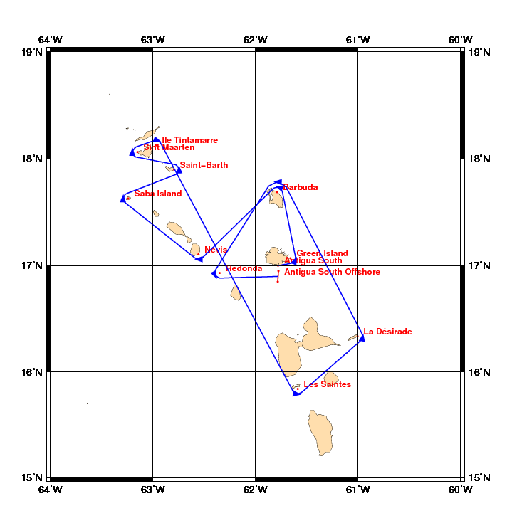
Chart and Info: Caribbean Sprint 2010
Start time: Feb 22 2010 15:00:00 UTC

Start by Antigua South at position: 17N00.0000 061W46.8000

Marks:

BRG is the bearing from ship to mark at scoring position.

 1: Green Island           - pass East  of 17N04.1220 061W39.5700 - BRG 294
 2: Barbuda                - pass North of 17N41.4000 061W47.4000 - BRG 200
 3: Nevis                  - pass South of 17N06.4200 062W33.3600 - BRG 000
 4: Saba Island            - pass West  of 17N37.8000 063W14.4600 - BRG 093
 5: Saint-Barth            - pass East  of 17N54.0000 062W47.7000 - BRG 267
 6: Sint Maarten           - pass West  of 18N03.8400 063W09.1200 - BRG 093
 7: Ile Tintamarre         - pass North of 18N07.5480 062W58.2780 - BRG 200
 8: Les Saintes            - pass South of 15N50.3400 061W35.3400 - BRG 009
 9: La Désirade            - pass East  of 16N20.1000 061W00.3000 - BRG 280
10: Barbuda                - pass North of 17N41.4000 061W47.4000 - BRG 183
11: Redonda                - pass West  of 16N55.9223 062W20.9542 - BRG 064

Finish line:

Line by Antigua South Offshore between marks A and B at positions:

 A: 16N57.0070 061W46.6160
 B: 16N50.9930 061W46.9839