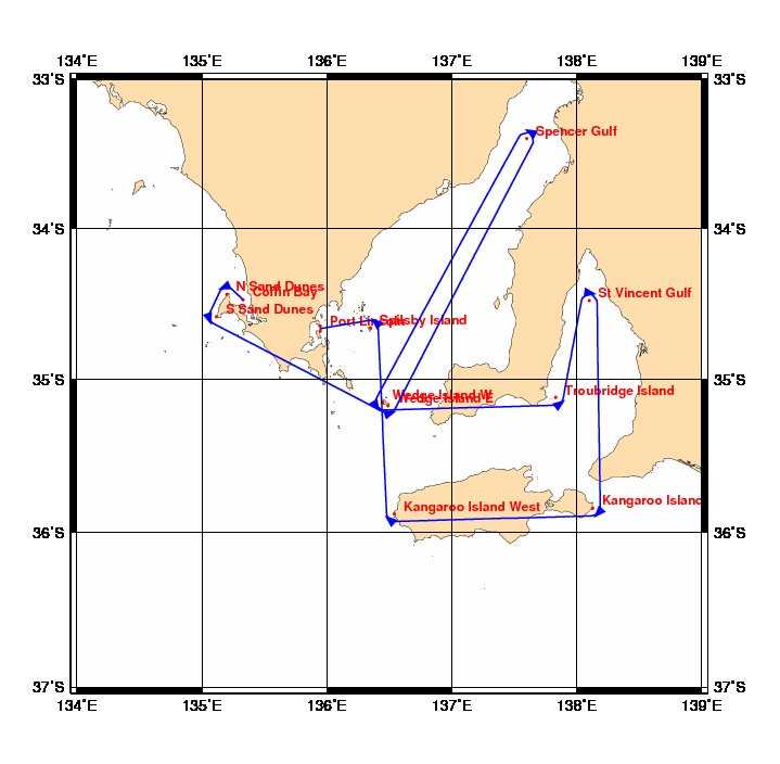
Chart and Info: AGage's Tour Down Under 2012 (687nm)
Start time: Jul 17 2012 06:00:00 UTC

Start by Coffin Bay at position: 34S28.5000 135E19.8000

Marks:

BRG is the bearing from ship to mark at scoring position.

 1: N Sand Dunes         - Leave 34S26.2800 135E12.0000 to Port      - BRG 157
 2: S Sand Dunes         - Leave 34S35.1600 135E07.0200 to Port      - BRG 071
 3: Wedge Island E       - Leave 35S10.4400 136E29.4000 to Port      - BRG 342
 4: Spencer Gulf         - Leave 33S24.0000 137E36.0000 to Port      - BRG 208
 5: Wedge Island W       - Leave 35S09.1200 136E26.8980 to Port      - BRG 058
 6: Troubridge Island    - Leave 35S07.1880 137E49.8420 to Port      - BRG 323
 7: St Vincent Gulf      - Leave 34S28.8000 138E06.0000 to Starboard - BRG 189
 8: Kangaroo Island East - Leave 35S50.5800 138E07.6200 to Starboard - BRG 313
 9: Kangaroo Island West - Leave 35S52.8000 136E32.4000 to Starboard - BRG 040
10: Spilsby Island       - Leave 34S39.6000 136E21.0000 to Port      - BRG 221

Finish line:

Line by Port Lincoln between marks A and B at positions:

 A: 34S40.9016 135E56.8984
 B: 34S38.8984 135E56.8616